Extensive Use of Habitat-Damaging Fishing Gears Inside Habitat-Protecting Marine Protected Areas
 Allison L. Perry
 Jorge Blanco
 Silvia García
 Nicolas Fournier
- 1Oceana, Madrid, Spain
- 2Oceana, Brussels, Belgium
Marine protected areas (MPAs) are critical for halting marine biodiversity loss and safeguarding ecosystems. However, efforts to designate additional areas as MPAs have generally taken precedence over ensuring that designated sites are effectively protected. Serious concerns exist about marine “paper parks” in Europe, particularly in relation to the threat of fishing. We focussed on 1,945 MPAs in EU and UK waters that are designated to protect habitats, and assessed the extent of fishing inside them with gears that are known to directly threaten those same habitats. Such “high-risk” fishing was widespread, occurring within 510 MPAs that represented 86% of the area assessed, and was more prevalent in larger, offshore sites. More intense high-risk fishing inside reef and sandbank MPAs was associated with the poorer conservation status of those habitats in countries’ waters. Our findings indicate that without systematic restrictions on damaging fishing gears, MPAs are unlikely to help reverse the ongoing declines of European marine habitats.
Introduction
In the face of severe human pressure on the marine environment, marine protected areas (MPAs) are a critical tool for safeguarding biodiversity and maintaining and recovering ecosystems. During the past decade, efforts to expand MPA networks have been partly driven by global targets, particularly the aim of conserving at least 10% of coastal and marine areas by 2020, as agreed under the United Nations Convention on Biological Diversity (CBD) and Sustainable Development Goal 14 (Convention on Biological Diversity [CBD], 2013; United Nations, 2015). The need to protect significantly more marine area (O’Leary et al., 2016) has gained political recognition in the lead-up to the adoption of a post-2020 global biodiversity framework, with nearly 70 countries making commitments to protect at least 30% of the ocean by 2030 (High Ambition Coalition for Nature and People, 2021).
These targets are important for setting the course for action, yet have inadvertently led to a “race to designate” in which a critical aspect of the CBD and Sustainable Development Goal 14 targets has been ignored: neither target is about designation only, but instead call for MPAs that deliver effective conservation (Convention on Biological Diversity [CBD], 2013; United Nations, 2015). In the process towards achieving spatial protection, designation is merely one step (Sala et al., 2018). Without effective management, designated MPAs remain “paper parks” that provide little to no real protection, while creating a false impression of success.
The gap between designated and effective MPAs is increasingly apparent in Europe. In 2018, the European Union (which then included the United Kingdom) announced that it had met its international commitments ahead of the 2020 deadline, by designating 10.8% of its marine area as MPAs (European Commission [EC], 2018). Recent studies, however, have highlighted serious management failings associated with European MPAs (WWF, 2019; Claudet et al., 2020; Perry et al., 2020). Particular concerns have been raised about the impacts of fishing (European Environment Agency [EEA], 2019a), one of the most widespread threats reported within MPAs in Europe (Mazaris et al., 2019). For example, commercial trawling has been documented in 59% of Atlantic and Baltic Sea MPAs (Dureuil et al., 2018). Overall, European MPAs have failed to provide real protection (European Court of Auditors, 2020), and most protected marine habitats and species are of poor or unknown conservation status (European Environment Agency [EEA], 2020).
Most MPAs in the EU and UK are designated for individual features (i.e., species and/or habitats), which has given rise to a management approach that aims to avoid direct impacts only on those designated features, rather than a “whole-site” approach that considers the ecological integrity of MPAs (Rees et al., 2013; Solandt et al., 2020). To evaluate the effectiveness of European MPAs, it is important to understand whether they provide even this minimal level of feature-based protection. Here, we address this question by focusing on one of the most significant threats to marine ecosystems in Europe: fishing with habitat-damaging gears (European Environment Agency [EEA], 2019a). The impacts of such gears on benthic ecosystems have been widely documented, and include direct physical damage to the seabed and biogenic structures, reductions in biomass and species richness, and broadscale changes in ecosystem structure and function (Hall, 1999; Collie et al., 2000; Hall-Spencer and Moore, 2000; Jennings et al., 2001; Hall-Spencer et al., 2002; Sampaio et al., 2012; Eigaard et al., 2015; Eggleton et al., 2018). Studies within European MPAs have further highlighted specific examples of fisheries damage to vulnerable habitats (see Table 1), and also demonstrated their recovery following the cessation of damaging fishing activities (e.g., Guillén et al., 1994; Sheehan et al., 2013).
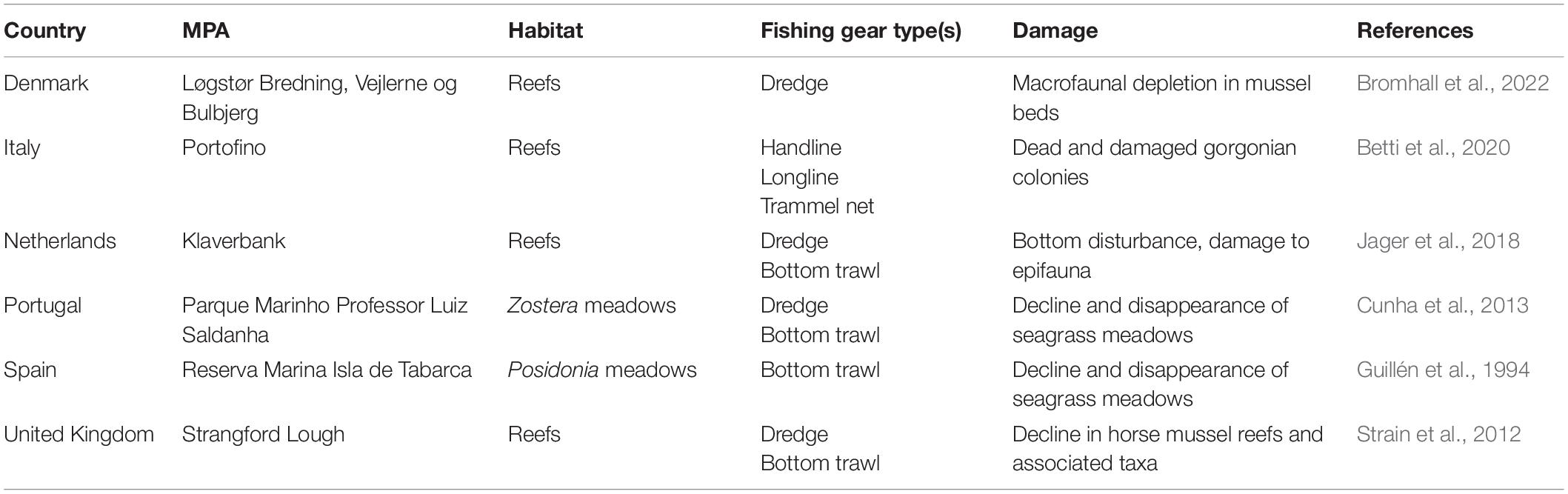
Table 1. Examples of documented cases of fisheries damage to vulnerable seabed habitats inside European marine protected areas (MPAs).
Specifically, we assess the extent, inside 1945 EU and UK MPAs that are designated for habitat protection, of “high-risk” fishing activities: fishing with gear types that are known to pose a direct threat to those specific habitats. We examine whether the intensity of high-risk fishing differs according to MPA distance from the coast or the habitats for which sites are designated. We also explore whether more intense high-risk fishing is associated with poorer conservation status of protected habitats in European waters.
Materials and Methods
Selection of Sites
We focused on the largest network of European MPAs (the Natura 2000 network), which accounts for nearly 70% of the protected marine area in the EU and the United Kingdom. Specifically, we selected those Natura 2000 MPAs that are designated (solely or partially) for the protection of marine habitats, under the EU Habitats Directive (Council Directive 92/43/EEC). Considering only these MPAs allowed for clearer comparisons across habitat types and sites, because they have been designated under a consistent legal framework.
We first identified MPAs within the Natura 2000 network, applying the method used by the European Environment Agency (European Environment Agency [EEA], 2015). As there is no official list of Natura 2000 MPAs, this method draws on complementary data sources that describe the network: tabular data detailing the characteristics of all Natura 2000 sites (both terrestrial and marine), and spatial data depicting their boundaries (European Environment Agency [EEA], 2019b). Using data reported to the European Commission by Member States at the end of 2018, we identified 2,090 sites within the tabular data that were designated under the Habitats Directive and included marine habitats as designated features (unlike the EEA, we included sites with coastal lagoons, on the basis of the species and habitats that they support). From the spatial data, we identified 3,967 sites with area lying seaward of the coastline (European Environment Agency [EEA], 2018). Finally, we combined the tabular and spatial data, and selected sites which could be identified as MPAs according to both datasets. The resulting 1,945 MPAs were located across the waters of all 23 countries (22 EU Member States and the United Kingdom) within the Natura 2000 MPA network. They comprised both types of sites designated under the Habitats Directive: Sites of Community Importance and Special Areas of Conservation. Countries are legally required to avoid the deterioration of designated habitats within these sites.
All spatial data analyses were performed using ArcGIS Pro 2.6.0 (Environmental Systems Research Institute, 2020).
High-Risk Fishing Activities
To quantify and assess fishing activities, we used data from Global Fishing Watch1 (GFW), a free online tool that uses public broadcast data from an automatic identification system (AIS), collected by satellite and terrestrial receivers, to show the movement of fishing vessels over time. GFW applies a convolutional neural network algorithm to this global feed of AIS data to differentiate apparent fishing activity from non-fishing (i.e., transiting) activity, based on parameters such as speed, direction, and rate of turn (Kroodsma et al., 2018).
We obtained GFW data describing fishing activities in EU waters (including the United Kingdom) between January and December 2018. These data comprised 67,981,179 points corresponding to vessel locations during apparent fishing activities. We confirmed active vessels from the EU by matching International Radio Call Signs and Community Fishing Fleet Register numbers to the EU Fleet Register (European Commission [EC], n.d.-a). We cross-checked data from GFW with fishing gear information from the EU Fleet Register, and classified vessels according to their primary gear types. These data provided a conservative estimate of fishing effort, as they only included those vessels that transmitted AIS signals. EU law requires AIS for vessels over 15 m length (Council Regulation (EC) No 1224/2009), meaning that AIS data are not complete for vessels below that length, which represent a large proportion of the fleet in certain regions (such as the Baltic and Mediterranean Seas), particularly in coastal areas.
We then applied a matrix of potential vulnerability of Natura 2000 habitats to different fishing methods (The N2K Group – European Economic Interest Group, 2014) to the GFW data. Using GIS, we identified “high-risk” fishing activities within each MPA: those interactions between the nine marine habitat types that are designated features of sites (Boreal Baltic narrow inlets, coastal lagoons, estuaries, large shallow inlets/bays, mudflats and sandflats, Posidonia beds, reefs, sandbanks, and submarine structures made by leaking gases) and gear types to which those habitats are highly vulnerable (Supplementary Table 1). We calculated the total number of hours apparently spent by vessels engaged in high-risk fishing during 2018, to estimate annual high-risk fishing effort per habitat type and per MPA. We then standardised these estimates to allow comparisons among MPAs; we divided annual high-risk fishing effort by MPA area, to yield annual intensities of high-risk fishing (h/km2).
Status of Protected Habitats
We compiled data about the conservation status of marine habitats listed in the Habitats Directive, as submitted to the European Commission by EU Member States and the United Kingdom (European Environment Information and Observation Network, 2020). These data covered the most recent reporting period (from 2013 to 2018), for the nine habitat types for which high-risk fishing was identified. Within these assessments, the conservation status of each habitat type was categorised as “favourable,” “unfavourable-inadequate,” or “unfavourable-bad,” for each marine region (i.e., Atlantic, Baltic, Black Sea, Macaronesia, and Mediterranean) within the entire territory of each country. For most countries, the assessments covered the entirety of national waters; in seven countries with waters in multiple marine regions (Denmark, France, Germany, Portugal, Spain, Sweden, and the United Kingdom), separate assessments were available for each region. For clarity, we refer to each spatial reporting unit as an “assessment area.”
Statistical Analyses
We used t-tests to explore variation in MPAs with and without high-risk fishing; specifically, we compared log-transformed areas and log(x + 1)-transformed distances from the coast between these two groups of sites. We then used chi-square goodness-of-fit tests to compare the observed number and proportion of MPAs designated for each habitat type that were subject to high-risk fishing to the expected number (calculated from the overall proportion of sites designated for each habitat type) and the expected proportion (calculated assuming no differences among designated habitat types in the proportion of sites affected) of MPAs, respectively.
We explored the broader impacts of high-risk fishing on protected habitats by assessing, for each habitat type, whether intensities of high-risk fishing inside MPAs differed among assessment areas categorised as “favourable,” “unfavourable-inadequate,” or “unfavourable-bad.” We tested for these differences among conservation status categories with one-way ANOVA on the log(x + 1)-transformed intensity of fishing inside MPAs, averaged at the scale of assessment areas, followed by Tukey HSD post-hoc tests.
All statistical analyses were carried out using the programme SPSS (IBM Corp, 2020).
Results
During 2018, a total of 1,011,473.1 h of high-risk fishing occurred inside Natura 2000 MPAs that are designated for marine habitat protection (Table 2). These fishing activities took place in the waters of all 23 countries within the Natura 2000 MPA network (Figure 1). Of the MPAs assessed, 510 (26%) were subject to high-risk fishing. These sites represented 86% of the 384,000 km2 of total area designated for habitat protection.
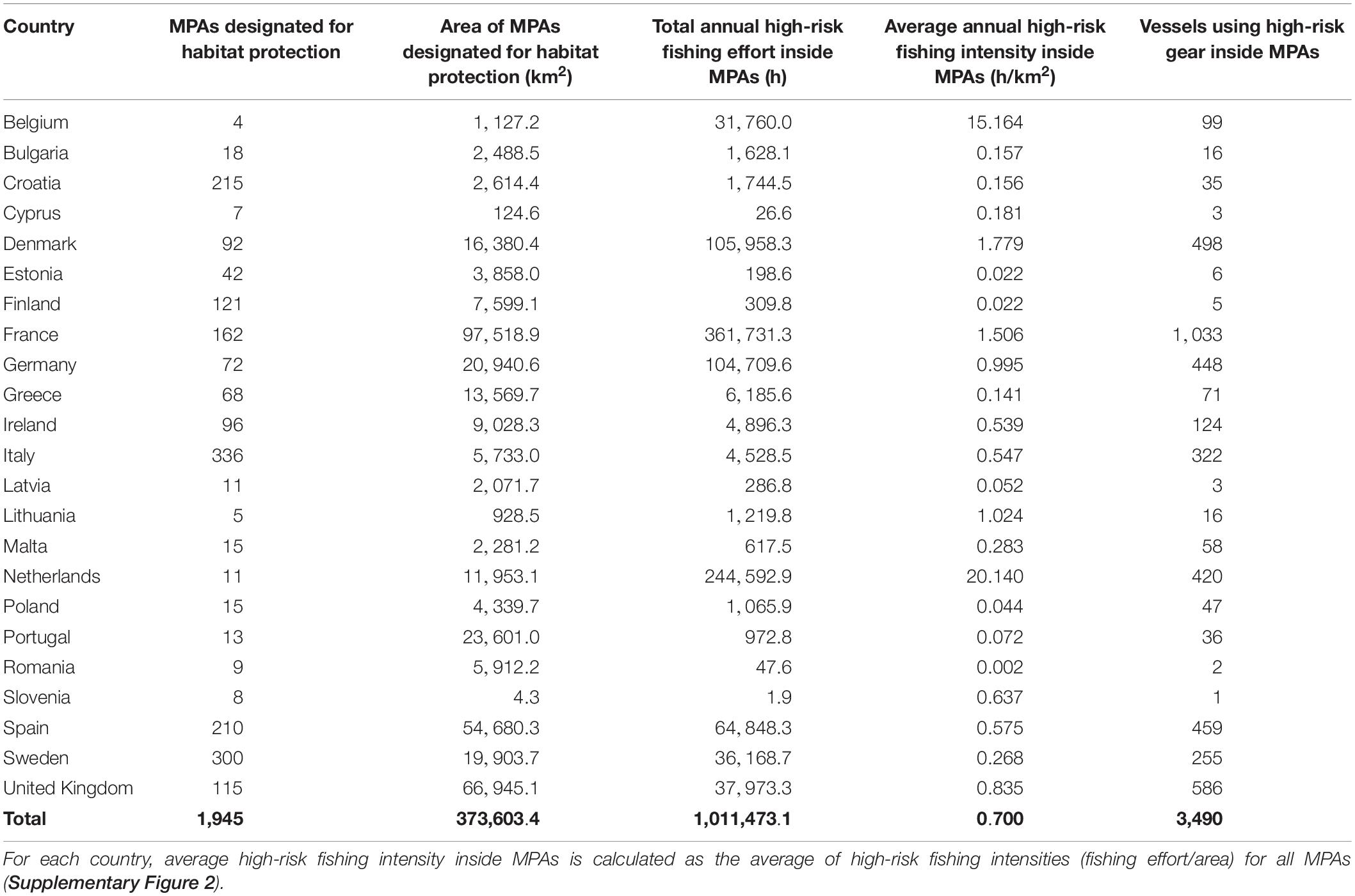
Table 2. Summary, by country, of Natura 2000 marine protected areas (MPAs) designated for habitat protection under the EU Habitats Directive, and annual high-risk fishing activity inside those MPAs during 2018.
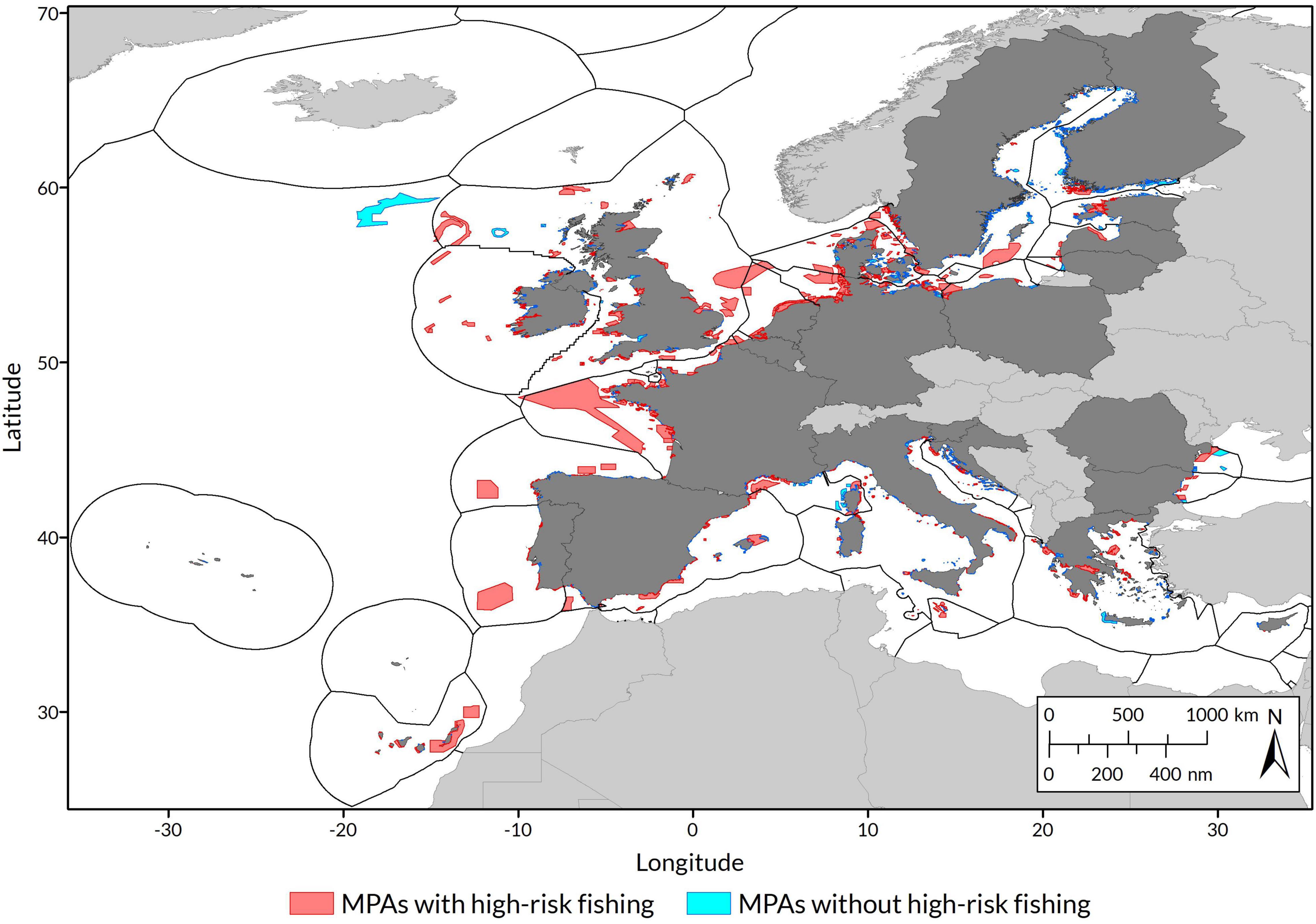
Figure 1. Occurrence of high-risk fishing within marine protected areas (MPAs) designated for habitat protection under the EU Habitats Directive. Countries whose waters were included in the analysis (marine EU Member States and the United Kingdom) are shaded dark grey.
MPAs with high-risk fishing were significantly larger [mean area (±95% CIs) = 87.46 km2 (73.64–103.87 km2)] than those without high-risk fishing [mean area (±95% CIs) = 1.89 km2 (1.65–2.17 km2)] (independent t-test: t1182.91 = –34.32, P < 0.001; Supplementary Figure 1). Eighty-two percent of MPAs without high-risk fishing were smaller than 20 km2, which is the minimum size that is typically recommended in Europe for MPA effectiveness (Wolters et al., 2015). Sites with high-risk fishing were also located further from shore [mean distance (±95% CIs) = 7.97 km (5.35–11.65 km)] than those without high-risk fishing [mean distance (±95% CIs) = 0.46 km (0.34–0.59 km)] (independent t-test: t573.32 = –10.04, P < 0.001; Supplementary Figure 1).
The threat of high-risk fishing inside MPAs was not equal across protected habitat types, in terms of the number of MPAs affected (χ2 = 357.60, df = 8, P < 0.001; Figure 2). High-risk fishing was most prevalent in MPAs designated for reefs (n = 417), sandbanks (n = 256), and Posidonia beds (n = 134). Proportionately, high-risk fishing was most common in sites designated to protect submarine structures made by leaking gases, occurring inside 70% of those MPAs (n = 19) that are intended to protect this fragile habitat type (χ2 = 128.65, df = 8, P < 0.001).
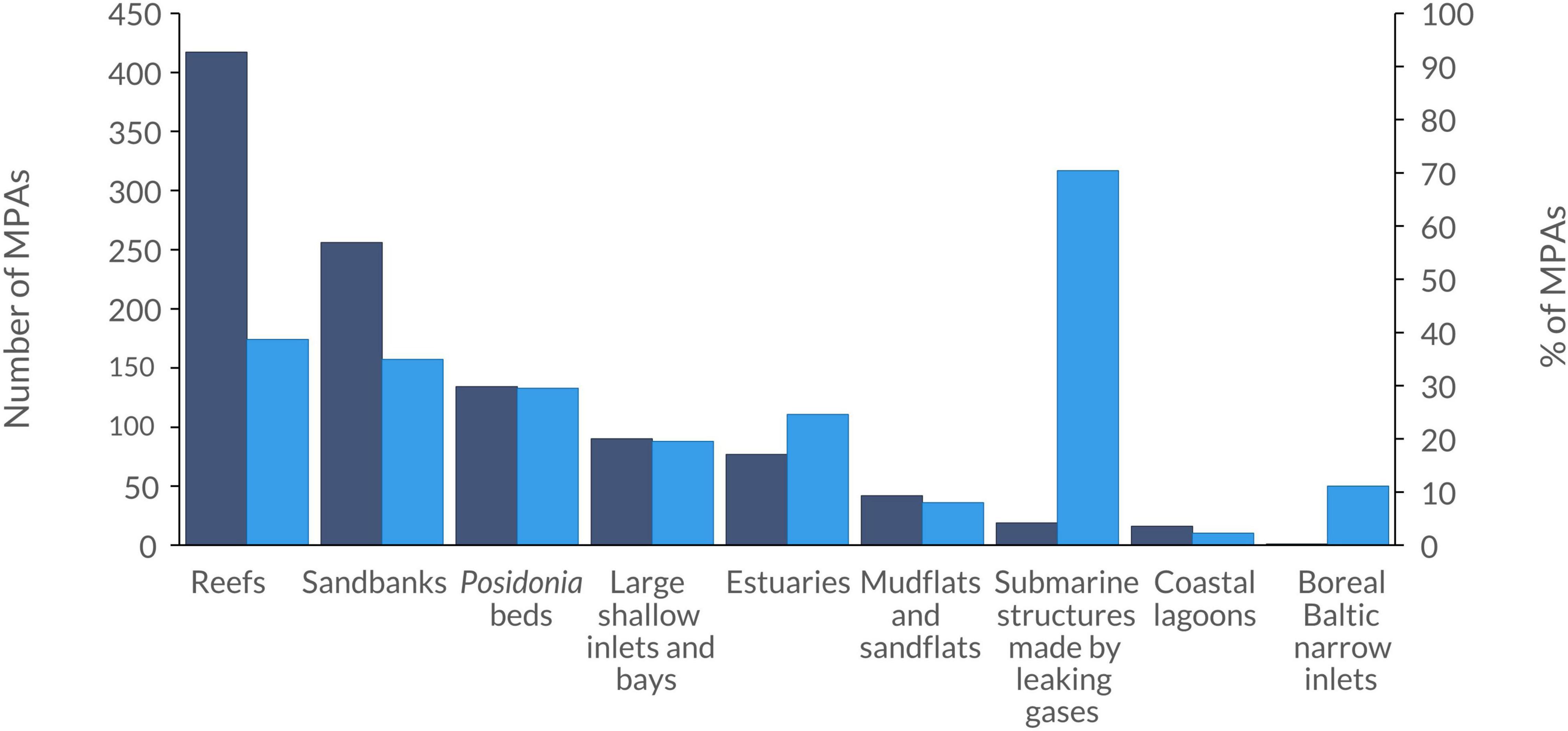
Figure 2. Marine protected areas (MPAs) that were subject to high-risk fishing, according to the habitat types for which they were designated. Dark blue bars indicate the number of MPAs with high-risk fishing, and light blue bars show the percentage of all MPAs designated for each habitat type that were subject to high-risk fishing.
Differences in high-risk fishing intensity relative to conservation status could be assessed for eight of the nine habitat types associated with high-risk fishing; Boreal Baltic narrow inlets were excluded due to small sample size. For reefs and sandbanks, intensities of high-risk fishing within MPAs were higher in assessment areas with poorer conservation status (reefs: F2,24 = 4.0, P = 0.03; sandbanks: F2,19 = 5.6, P = 0.012). For both habitat types, high-risk fishing intensity inside MPAs was significantly higher in assessment areas categorised as “unfavourable-bad” than in those categorised as “favourable” (Figure 3). For the remaining six habitat types, high-risk fishing intensity did not differ significantly according to conservation status (Supplementary Table 2).
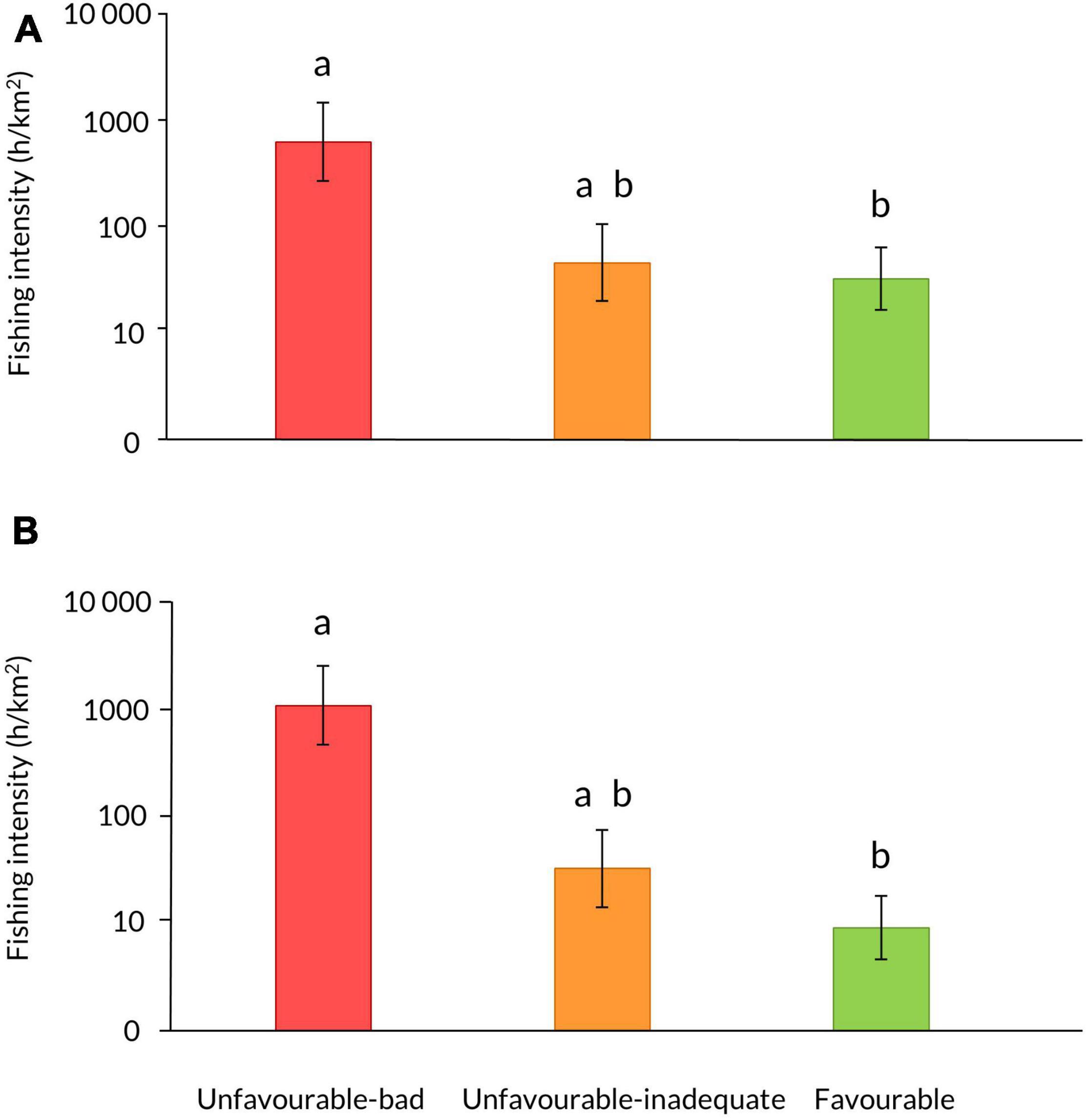
Figure 3. Intensity of high-risk fishing (mean ± SE, shown on a log scale) in MPAs designated for (A) reefs and (B) sandbanks, within assessment areas categorised by the conservation status of those habitats. Different letters above bars indicate significant differences (P < 0.05) from post-hoc tests.
Discussion
Extensive areas of the European seabed are exposed to damaging fishing gears (European Environment Agency [EEA], 2019a), and even within MPAs, fishing represents the main pressure on seabed habitats (Aronsson et al., 2015). Our analysis revealed that the use of habitat-damaging fishing gears is pervasive across EU and UK MPAs that are intended to protect marine habitats. We identified 510 MPAs (representing 86% of the area of sites assessed) that were designated for the protection of habitats yet permitted fishing activities that pose a recognised threat to those very habitats. Such high-risk fishing was more common in larger, offshore sites, as well as within MPAs designated for the protection of reefs, sandbanks, and Posidonia beds. For reefs and sandbanks, more intense high-risk fishing inside MPAs was associated with poorer conservation status within countries’ waters.
These results indicate that without a radical shift in approach to fisheries management, MPAs are unlikely to help reverse the ongoing decline of marine habitats (European Environment Agency [EEA], 2020). We documented high-risk fishing inside habitat-protecting MPAs of all 23 countries within the Natura 2000 MPA network, which suggests that weaknesses in fisheries management are systemic and thus require a regional-scale response. Our findings add to previous concerns raised that some of the most damaging fishing gears (i.e., bottom trawls) are used more intensively inside some European MPAs than in unprotected waters (Dureuil et al., 2018).
The prevalence of high-risk fishing in larger, offshore MPAs partly reflects the nature of the fisheries management framework for MPAs under the EU Common Fisheries Policy (Regulation (EU) No 1380/2013). EU Member States may unilaterally establish fisheries management measures within some of their MPAs, such as sites that are inshore (i.e., located within the 12 nautical mile zone) or those not fished by other Member States. However, measures for offshore sites that are subject to multiple fishing interests must be proposed through a “joint recommendation” from the countries concerned. To date, countries have shown limited engagement in this process. Since 2015, only six joint recommendations have been adopted, covering 19 MPAs in two countries, out of 118 offshore MPAs that have been designated under the Habitats Directive (European Commission [EC], n.d.-b). The process has been further criticised for its ineffectiveness, as damaging activities continue during protracted negotiations that often result in weaker restrictions than those that were initially proposed (European Court of Auditors, 2020).
Elevated pressure on offshore MPAs was also apparent in the greater incidence of high-risk fishing on all three designated habitat types found in offshore waters: reefs, sandbanks, and submarine structures formed by leaking gases. For both reefs and sandbanks, more intense high-risk fishing inside MPAs was associated more broadly with poorer conservation status in EU and UK waters. This could reflect the fact that habitat status may be more directly linked to levels of fishing pressure in offshore waters, where other threats are less pronounced than in coastal areas (European Environment Agency [EEA], 2019a; Korpinen et al., 2019). It may also relate to sites being designated because they represent the most extensive or best conserved examples of features (European Commission [EC], 2007). If habitats inside such MPAs experience damaging fishing, it is unsurprising that the impacts are visible in terms of overall conservation status, particularly if fishing intensity inside MPAs is also indicative of fishing pressure in unprotected areas.
The greater observed incidence of high-risk fishing in larger, offshore sites may also partly relate to limitations in the fishing effort data used. Because AIS is only legally required for EU fishing vessels over 15 m length, AIS data provide a better indication of the fishing activity of larger vessels. Such vessels can fish further offshore, where larger MPAs also tend to be located (Figure 1). Despite this limitation, our main finding remains unchanged: habitat-damaging fishing gears are widely used across the largest network of European MPAs that are meant to protect benthic habitats. Unfortunately, comprehensive spatial data describing the fishing effort of small-scale vessels are not available at the scale of our analyses. These gaps in coverage of fishing effort data for smaller vessels mean that we are likely to have underestimated the real extent of high-risk fishing inside MPAs, particularly for coastal areas and the habitats associated with them, such as coastal lagoons, estuaries, and Posidonia beds.
It is worth noting that we considered high-risk fishing activities inside MPAs that are designated to protect specific habitats, but that this does not imply that high-risk fishing gears are necessarily being used directly over those habitats. Fishing activities may be concentrated in particular areas or habitats inside MPAs, and some sites may be managed through zonation-based approaches that restrict the use of certain gears where specific features are known to occur. However, it was not possible to examine fishing-habitat interactions at a finer resolution (i.e., within individual sites), because detailed habitat maps are lacking, incomplete, or not publicly available for many Natura 2000 MPAs (EMODnet, 2021). Nevertheless, our findings indicate that the use of high-risk fishing gears is likely to directly contravene the conservation aims of MPAs, either because fisheries management measures are absent, or because such measures restrict fishing only in the precise locations where designated features have been mapped and therefore provide no protection to designated features that have not been sufficiently documented, or to other features within sites. The latter is an inherent weakness of feature-based MPA management, which ignores the ecological integrity of sites (Rees et al., 2013). This approach is also detrimental to any restoration possibilities of sites, another objective of the Natura 2000 network, as continuous high-risk fishing may prevent the regeneration of protected habitats beyond their existing distributions. In addition, allowing certain types of high-risk fishing (e.g., bottom trawling) around mapped features may also limit their potential restoration and expansion, because of the associated resuspension and displacement of sediments, organic materials, and contaminants over large distances underwater (Daly et al., 2018; Linders et al., 2018). More broadly, such disturbance of seafloor sediments—which represent a critical store of organic carbon—also raises concerns about the impacts on the global carbon sink (Cavan and Hill, 2022) and the reduced capacity of weakly protected MPAs to help mitigate climate change (Atwood et al., 2020).
Our findings provide compelling evidence that European MPAs are failing to curb the use of damaging fishing gears on protected habitats. As such, they also strongly indicate that countries are failing to meet their legal obligations to avoid habitat deterioration within sites. The EU and the UK have recognised the vital role of MPAs in halting marine biodiversity loss, committing to 30% marine protection by 2030, including the designation of strictly protected areas (Department for Environment, Food and Rural Affairs et al., 2018; European Commission [EC], 2020). However, the expansion of MPA networks must be matched with equally ambitious policies to strengthen management, to ensure that both existing and new MPAs provide actual protection.
In relation to fisheries, we argue that redressing MPA management failings requires a drastically scaled-up approach. First, countries should adopt a “whole-site” approach to MPA management, to better conserve and recover designated features while safeguarding ecosystem processes and functions (Solandt et al., 2020; Pikesley et al., 2021). This would involve establishing broader restrictions on fishing activities that contravene MPA conservation aims, rather than limitations only precisely where designated features have been identified. Second, a systematic “whole-network” approach is also required, to go beyond inconsistent site-specific measures, and recognise that damaging gears are fundamentally incompatible with MPA objectives. Detailed assessments of the highest-risk interactions between specific gears and conservation features (e.g., Marine Management Organisation, 2014; The N2K Group – European Economic Interest Group, 2014) provide a clear basis for adopting such network-wide restrictions (Clark et al., 2017), which would allow the much swifter introduction of fisheries management measures than current site-by-site approaches, ensure consistency across sites, and facilitate monitoring and enforcement. The alternative—continuing with minimal, patchy management of damaging fishing inside MPAs—risks leaving Europe as a global leader in the creation of marine paper parks.
Data Availability Statement
Publicly available datasets were analysed in this study. The Natura 2000 data and shapefiles used in this study are freely available from the European Environment Agency (https://www.eea.europa.eu/data-and-maps/data/natura-11). Full data on fishing activities are available by request from Global Fishing Watch (https://globalfishingwatch.org).
Author Contributions
AP conceived and designed the study and performed the statistical analyses. AP, JB, and SG were involved in compiling and processing the data. JB performed the spatial data analyses. AP wrote the manuscript with contributions from JB, SG, and NF. All authors have read and approved the submitted version.
Funding
This research was funded by Stichting the Flotilla Charitable Foundation and the European Commission’s LIFE Programme.
Conflict of Interest
The authors declare that the research was conducted in the absence of any commercial or financial relationships that could be construed as a potential conflict of interest.
Publisher’s Note
All claims expressed in this article are solely those of the authors and do not necessarily represent those of their affiliated organizations, or those of the publisher, the editors and the reviewers. Any product that may be evaluated in this article, or claim that may be made by its manufacturer, is not guaranteed or endorsed by the publisher.
Acknowledgments
We gratefully acknowledge Global Fishing Watch for sharing data on commercial fishing activity. We also thank Jennifer Gill for providing valuable feedback on the analyses, and Vera Coelho and two reviewers for their helpful comments on the manuscript.
Supplementary Material
The Supplementary Material for this article can be found online at: https://www.frontiersin.org/articles/10.3389/fmars.2022.811926/full#supplementary-material
Footnote
References
Aronsson, M., Bailly Maitre, J., Gavilan, L.-P., and Richard, D. (2015). “Pre-scoping document for the marine regions (1st part: Core document),” in European Topic Centre on Biological Diversity [ETC/BD] Technical Paper 2/2015, (Paris: ETC/BD), 42.
Atwood, T. B., Witt, A., Mayorga, J., Hammill, E., and Sala, E. (2020). Global patterns in marine sediment carbon stocks. Front. Mar. Sci. 7:165. doi: 10.3389/fmars.2020.00165
Betti, F., Bavestrello, G., Bo, M., Ravanetti, G., Enrichetti, F., Coppari, M., et al. (2020). Evidences of fishing impact on the coastal gorgonian forests inside the Portofino MPA (NW Mediterranean Sea). Ocean Coast Manag. 187:105105. doi: 10.1016/j.ocecoaman.2020.105105
Bromhall, K., Dinesen, G. E., McLaverty, C., Eigaard, O. R., Petersen, J. K., and Saurel, C. (2022). Experimental effects of a lightweight mussel dredge on benthic fauna in a eutrophic MPA. J. Shellfish Res. 40, 519–531. doi: 10.2983/035.040.0309
Cavan, E. L., and Hill, S. L. (2022). Commercial fishery disturbance of the global ocean biological carbon sink. Glob. Change Biol. 28, 1212–1221. doi: 10.1111/gcb.16019
Clark, R., Humphreys, J., Solandt, J. L., and Weller, C. (2017). Dialectics of nature: the emergence of policy on the management of commercial fisheries in English European Marine Sites. Mar. Policy 78, 11–17. doi: 10.1016/j.marpol.2016.12.021
Claudet, J., Loiseau, C., Sostres, M., and Zupan, M. (2020). Underprotected Marine Protected Areas in a Global Biodiversity Hotspot. One Earth 2, 380–384. doi: 10.1016/j.oneear.2020.03.008
Collie, J. S., Hall, S. J., Kaiser, M. J., and Poiner, I. R. (2000). A quantitative analysis of fishing impacts on shelf-sea benthos. J. Anim. Ecol. 69, 785–798. doi: 10.1046/j.1365-2656.2000.00434.x
Convention on Biological Diversity [CBD] (2013). Quick Guides to the Aichi Biodiversity Targets. Version 2. Available online at: https://www.cbd.int/doc/strategic-plan/targets/compilation-quick-guide-en.pdf (accessed on Nov 22, 2018)
Cunha, A. H., Assis, J. F., and Serrão, E. A. (2013). Seagrasses in Portugal: a most endangered marine habitat. Aquat. Bot. 104, 193–203. doi: 10.1016/j.aquabot.2011.08.007
Daly, E., Johnson, M. P., Wilson, A. M., Gerritsen, H. D., Kiriakoulakis, K., Allcock, A. L., et al. (2018). Bottom trawling at Whittard Canyon: evidence for seabed modification, trawl plumes and food source heterogeneity. Prog. Oceanogr. 169, 227–240. doi: 10.1016/j.pocean.2017.12.010
Department for Environment, Food and Rural Affairs, Foreign & Commonwealth Office, The Rt Hon Thérèse Coffey MP, The Rt Hon Sir Alan Duncan KCMG, and The Rt Hon Michael Gove MP (2018). Gove Calls for 30 Percent of World’s Oceans to be Protected by 2030. Press Release, 24 September, 2018. Available online at: https://www.gov.uk/government/news/gove-calls-for-30-per-cent-of-worlds-oceans-to-be-protected-by-2030 (accessed on Oct 13, 2020)
Dureuil, M., Boerder, K., Burnett, K. A., Froese, R., and Worm, B. (2018). Elevated trawling inside protected areas undermines conservation outcomes in a global fishing hot spot. Science 362, 1403–1407. doi: 10.1126/science.aau0561
Eggleton, J. D., Depestele, J., Kenny, A. J., Bolam, S. G., and Garcia, C. (2018). How benthic habitats and bottom trawling affect trait composition in the diet of seven demersal and benthivorous fish species in the North Sea. J. Sea Res. 142, 132-146. doi: 10.1016/j.seares.2018.09.013
Eigaard, O. R., Bastardie, F., Breen, M., Dinesen, G. E., Hintzen, N. T., Laffargue, P., et al. (2015). Estimating seabed pressure from demersal trawls, seines, and dredges based on gear design and dimensions. ICES J. Mar. Sci. 73, i27–i43. doi: 10.1093/icesjms/fsv099
EMODnet (2021). Seabed Habitats. Available online at: https://www.emodnet-seabedhabitats.eu (accessed on Sep 3, 2021)
Environmental Systems Research Institute (2020). ArcGIS Pro: Version 2.6.0. Redlands, CA: Environmental Systems Research Institute.
European Commission [EC] (2007). Guidelines for the Establishment of the Natura 2000 Network in the Marine Environment. Application of the Habitats and Birds Directives. Available online at: https://ec.europa.eu/environment/nature/natura2000/marine/docs/marine_guidelines.pdf (accessed on Sep 2, 2021).
European Commission [EC] (2018). European Union Meets Target of Conserving 10% of Europe’s Seas by 2020. Press release, 28 October, 2018. Available online at: https://ec.europa.eu/info/news/european-union-meets-target-conserving-10-europes-seas-2020-2018-oct-29_en (accessed on Jul 23, 2020).
European Commission [EC] (2020). Communication from the Commission to the European Parliament, the Council, the European Economic and Social Committee and the Committee of the Regions. EU Biodiversity Strategy for 2030: Bringing nature back into our lives. (COM(2020) 380 final). Brussels: European Commission.
European Commission [EC] (n.d.-a) Data from: Fleet Register. Available online at: https://webgate.ec.europa.eu/fleet-europa/index_en.
European Commission [EC] (n.d.-b). Managing Fisheries. Available online at: https://ec.europa.eu/fisheries/cfp/fishing_rules_en (accessed onJan 31, 2021).
European Court of Auditors (2020). Marine Environment: EU Protection is Wide but Not Deep. European Court of Auditors Special Report 26/2020. Luxembourg: Publications Office of the European Union, 74. doi: 10.2865/134960
European Environment Agency [EEA] (2015). Spatial Analysis of Marine Protected Area Networks in Europe’s Seas. EEA Technical Report 17/2015. Luxembourg: Publications Office of the European Union, 70. doi: 10.2800/406625
European Environment Agency [EEA] (2018). Data from: EEA Coastline for Analysis. Luxembourg: Publications Office of the European Union.
European Environment Agency [EEA] (2019a). Marine Messages II: Navigating the Course Towards Clean, Healthy and Productive Seas Through Implementation of an Ecosystem-Based Approach. EEA Report 17/2019. Luxembourg: Publications Office of the European Union, 82. doi: 10.2800/71245
European Environment Agency [EEA] (2019b). Data from: Natura 2000 Data – the European Network of Protected Sites. Luxembourg: Publications Office of the European Union.
European Environment Agency [EEA] (2020). State of Nature in the EU: Results from Reporting Under the Nature Directives 2013-2018. EEA Report 10/2010. Luxembourg: Publications Office of the European Union, 146. doi: 10.2800/705440
European Environment Information and Observation Network (2020). Data from: Reporting under Article 17 of the Habitats Directive. Luxembourg: Publications Office of the European Union.
Guillén, J. E., Ramos, A. A., Martínez, L., and Sánchez Lizaso, J. L. (1994). Antitrawling reefs and the protection of Posidonia oceanica (L.) Delile meadows in the Western Mediterranean Sea: Demand and aims. Bull. Mar. Sci. 55, 645–650.
Hall, S. J. (1999). The Effects of Fishing on Marine Ecosystems and Communities. Oxford, UK: Blackwell Science.
Hall-Spencer, J., Allain, V., and Fosså, J. H. (2002). Trawling damage to Northeast Atlantic ancient coral reefs. Proc. R. Soc. Lond. B 269, 507–511. doi: 10.1098/rspb.2001.1910
Hall-Spencer, J. M., and Moore, P. G. (2000). Scallop dredging has profound, long-term impacts on maerl habitats. ICES J. Mar. Sci. 57, 1407–1415. doi: 10.1006/jmsc.2000.0918
High Ambition Coalition for Nature and People (2021). High Ambition Coalition for Nature and People. Available online at: https://www.hacfornatureandpeople.org/ (accessed on Sep 1, 2021)
Jager, Z., Witbaard, R., and Kroes, M. (2018). Impact of Demersal and Seine Fisheries in the Natura 2000-Area Cleaver Bank. NIOZ Report 2018-3. Texel: Netherlands Institute for Sea Research, 64.
Jennings, S., Pinnegar, J. K., Polunin, N. V. C., and Warr, K. J. (2001). Impacts of trawling disturbance on the trophic structure of benthic invertebrate communities. Mar. Ecol. Prog. Ser. 213, 127–142. doi: 10.3354/meps213127
Korpinen, S., Klanènik, K., Peterlin, M., Nurmi, M., Laamanen, L., Zupanèiè, G., et al. (2019). Multiple Pressures and Their Combined Effects in Europe’s Seas. European Topic Centre on Inland, Coastal and Marine Waters Technical Report 4/2019. Copenhagen: European Environment Agency, 164.
Kroodsma, D. A., Mayora, J., Hochberg, T., Miller, N. A., Boerder, K., Ferretti, F., et al. (2018). Tracking the global footprint of fisheries. Science 359, 904–908. doi: 10.1126/science.aao5646
Linders, T., Nilsson, P., Wikström, A., and Sköld, M. (2018). Distribution and fate of trawling-induced suspension of sediments in a marine protected area. ICES J. Mar. Sci. 75, 785–795. doi: 10.1093/icesjms/fsx196
Marine Management Organisation (2014). Guidance. Fisheries in European marine sites: Matrix. Available online at: https://www.gov.uk/government/publications/fisheries-in-european-marine-sites-matrix (accessed on Sep 2, 2021)
Mazaris, A. D., Kallimanis, A., Gissi, E., Pipitone, C., Danovaro, R., Claudet, J., et al. (2019). Threats to marine biodiversity in European protected areas. Sci. Total Environ. 677, 418–426. doi: 10.1016/j.scitotenv.2019.04.333
O’Leary, B. C., Winther-Janson, M., Bainbridge, J. M., Aitken, J., Hawkins, J. P., and Roberts, C. M. (2016). Effective coverage targets for ocean protection. Conserv. Lett. 9, 398–404. doi: 10.1111/conl.12247
Perry, A. L., Blanco, J., Fournier, N., García, S., and Marín, P. (2020). Unmanaged = Unprotected: Europe’s marine paper parks. Brussels: Oceana, 52. doi: 10.5281/zenodo.4312546
Pikesley, S. K., Solandt, J.-L., Trundle, C., and Witt, M. J. (2021). Benefits beyond ‘features’: cooperative monitoring highlights MPA value for enhanced seabed integrity. Mar. Policy 134:104801. doi: 10.1016/j.marpol.2021.104801
Rees, S. E., Sheehan, E. V., Jackson, E. L., Gall, S. C., Cousens, S. L., Solandt, J.-L., et al. (2013). A legal and ecological perspective of ‘site integrity’ to inform policy development and management of Special Areas of Conservation in Europe. Mar. Pollut. Bull. 72, 14–21. doi: 10.1016/j.marpolbul.2013.03.036
Sala, E., Lubchenco, J., Grorud-Colvert, K., Novelli, C., Roberts, C., and Sumaila, U. R. (2018). Assessing real progress towards effective ocean protection. Mar. Policy 91, 11–13. doi: 10.1016/j.marpol.2018.02.004
Sampaio, Í, Braga-Henriques, A., Pham, C., Ocaña, O., de Matos, V., Morato, T., et al. (2012). Cold-water corals landed by bottom longline fisheries in the Azores (north-eastern Atlantic). J. Mar. Biol. Assoc. UK 92, 1547–1555. doi: 10.1017/S0025315412000045
Sheehan, E. V., Stevens, T. F., Gall, S. C., Cousens, S. L., and Attrill, M. J. (2013). Recovery of a temperate reef assemblage in a marine protected area following the exclusion of towed demersal fishing. PLoS One 8:e83883. doi: 10.1371/journal.pone.0083883
Solandt, J.-L., Mullier, T., Elliott, S., and Sheehan, E. (2020). “Managing marine protected areas in Europe: moving from ‘feature-based’ to ‘whole-site’ management of sites,” in Marine Protected Areas: Science, Policy and Management, ed. J. Humphreys and R. W. E. Clarke, (Amsterdam: Elsevier), 157-181. doi: 10.1016/B978-0-08-102698-4.00009-5
Strain, E. M. A., Allcock, A. L., Goodwin, C. E., Maggs, C. A., Picton, B. E., and Roberts, D. (2012). The long-term impacts of fisheries on epifaunal assemblage function and structure, in a Special Area of Conservation. J. Sea Res. 67, 58–68. doi: 10.1016/j.seares.2011.10.001
The N2K Group – European Economic Interest Group (2014). Overview of the potential interactions and impacts of commercial fishing methods on marine habitats and species protected under the EU Habitats Directive. Available online at: https://ec.europa.eu/environment/nature/natura2000/marine/docs/Fisheriesinteractions.pdf interactions.pdf (accessed on Sep 30, 2019).
United Nations (2015). Transforming Our World: The 2030 Agenda for Sustainable Development. General Assembly Resolution A/Res/70/1. Available online at: https://sustainabledevelopment.un.org/post2015/transformingourworld/publication (accessed on Sep 2, 2021).
Wolters, H., Galparsoro, I., Castro, R., Korpinen, S., Nurmi, M., Tsangaris, C., et al. (2015). Proposal for an Assessment Method of the Ecological Coherence of Networks of Marine Protected Areas in Europe. Report 1208917-000-ZKS-0018 to the European Commission. Delft: Deltares. doi: 10.13140/rg.2.1.2382.8969
Keywords: destructive fishing, fisheries management, fishing impacts, marine habitats, marine protected areas, paper parks, whole-site approach
Citation: Perry AL, Blanco J, García S and Fournier N (2022) Extensive Use of Habitat-Damaging Fishing Gears Inside Habitat-Protecting Marine Protected Areas. Front. Mar. Sci. 9:811926. doi: 10.3389/fmars.2022.811926
Received: 09 November 2021; Accepted: 25 January 2022;
Published: 16 February 2022.
Edited by:
Lyne Morissette, M – Expertise Marine, CanadaReviewed by:
Jason Michael Hall-Spencer, University of Plymouth, United KingdomGert Van Hoey, Institute for Agricultural, Fisheries and Food Research (ILVO), Belgium
Copyright © 2022 Perry, Blanco, García and Fournier. This is an open-access article distributed under the terms of the Creative Commons Attribution License (CC BY). The use, distribution or reproduction in other forums is permitted, provided the original author(s) and the copyright owner(s) are credited and that the original publication in this journal is cited, in accordance with accepted academic practice. No use, distribution or reproduction is permitted which does not comply with these terms.
*Correspondence: Allison L. Perry, aperry@oceana.org